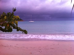
What a difference a few minutes make. The storm clouds moved in and it looks like we're about to get some major rain. We just ordered dinner at Island Beachcomber so hopefully it holds off for a little bit.
Tuesday, August 2, 2011


Wave action

Decided to stop by the Island Beachcomber to check out the wave action and it's pretty impressive. TS Emily is giving us some wind and seas but that's about it. They are calling for more rain and wind tonight so we will probably pull in the patio chairs but that's about it.
Tropical Storm Emily
Looks like we were spared the brunt of Emily. Here is the latest from VITEMA:
Alert / Warning
Meteorological - SPECIAL WEATHER STATEMENT
...This is an ACTUAL SPECIAL WEATHER STATEMENT ALERT...
Issued By: VITEMA
Affected Jurisdictions: Virgin Islands
Headline: Virgin Islands Under Tropical Storm Watch Through 9:30 a.m. Wednesday; Coastal Waters Under Tropical Storm Warning
The Virgin Islands remains under Tropical Storm Watch through 9:30 a.m. Wednesday as Tropical Storm Emily continues to move across the area. Emily is expected to pass south of the St. Croix at about 11 a.m. today, however, the latest forecast do not indicate that the Territory will receive significant rainfall with this system.
The opening of shelters on St. Croix, St. Thomas and St. John has been suspended.
A Tropical Storm Warning has been issued for the coastal waters surrounding the Virgin Islands with tropical storm conditions and remains in effect through Wednesday morning. Storm surge may raise water levels by one to two feet above normal tide levels and near the coast the surge will be accompanies by large and dangerous waves, according to the National Weather Service.
At 8 a.m. today, the center of Tropical Storm Emily was located near latitude 15.3 North, longitude 63.7 West. Emily is about 160 miles south southeast of St. Croix and is moving toward the west at 14 miles per hour and packing maximum sustained winds of 40 miles per hour with higher gusts. Tropical storm force winds extend outward up to 70 miles mainly to the north of the center.
According to the National Weather Service, the latest projected path of the storm indicates the core of the heaviest rains will remain over water and currently, there is little chance for hurricane conditions. Tropical Storm Emily is expected to turn toward the west-northwest and gradually decrease in forward speed during the next 48 hours.
VITEMA joins the National Weather Service in urging mariners to return to port, seek safe harbor, and secure their craft and to initiate preparations according to your emergency plan for tropical systems.
Along with the mariners, residents should also continue to monitor this storm system for any change while a storm Watch remains in effect. Stay tuned to radio and TV, and monitor NOAA weather radios and VI Alert for updated information on watches or warnings for this area.
Alert / Warning
Meteorological - SPECIAL WEATHER STATEMENT
...This is an ACTUAL SPECIAL WEATHER STATEMENT ALERT...
Issued By: VITEMA
Affected Jurisdictions: Virgin Islands
Headline: Virgin Islands Under Tropical Storm Watch Through 9:30 a.m. Wednesday; Coastal Waters Under Tropical Storm Warning
The Virgin Islands remains under Tropical Storm Watch through 9:30 a.m. Wednesday as Tropical Storm Emily continues to move across the area. Emily is expected to pass south of the St. Croix at about 11 a.m. today, however, the latest forecast do not indicate that the Territory will receive significant rainfall with this system.
The opening of shelters on St. Croix, St. Thomas and St. John has been suspended.
A Tropical Storm Warning has been issued for the coastal waters surrounding the Virgin Islands with tropical storm conditions and remains in effect through Wednesday morning. Storm surge may raise water levels by one to two feet above normal tide levels and near the coast the surge will be accompanies by large and dangerous waves, according to the National Weather Service.
At 8 a.m. today, the center of Tropical Storm Emily was located near latitude 15.3 North, longitude 63.7 West. Emily is about 160 miles south southeast of St. Croix and is moving toward the west at 14 miles per hour and packing maximum sustained winds of 40 miles per hour with higher gusts. Tropical storm force winds extend outward up to 70 miles mainly to the north of the center.
According to the National Weather Service, the latest projected path of the storm indicates the core of the heaviest rains will remain over water and currently, there is little chance for hurricane conditions. Tropical Storm Emily is expected to turn toward the west-northwest and gradually decrease in forward speed during the next 48 hours.
VITEMA joins the National Weather Service in urging mariners to return to port, seek safe harbor, and secure their craft and to initiate preparations according to your emergency plan for tropical systems.
Along with the mariners, residents should also continue to monitor this storm system for any change while a storm Watch remains in effect. Stay tuned to radio and TV, and monitor NOAA weather radios and VI Alert for updated information on watches or warnings for this area.
Sunday, July 31, 2011
First storm threat of the season
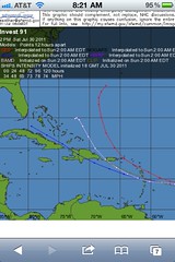
Well, preparations are being made for our first possible storm threat. Jay is hauling our boat out this afternoon and on Monday CYOA will be making a decision about securing their boats. I went to cost u less yesterday to stock up on a few items and today I'll be getting gas for the generator and gas grill. The condo we're in has accordion shutters on all the windows and doors so we're going to check them this morning to make sure they close. UVI preparedness committee will be meeting on Monday to put our plan in place. One of the storm tracks has it coming right over us but other tracks has it going south. It's supposed to be upgraded to a named storm later this morning, Emily. Keep your fingers crossed that it goes south.
From NOAA:
1. SATELLITE IMAGES AND NOAA BUOY DATA INDICATE THAT THE LARGE AND
ELONGATED LOW PRESSURE SYSTEM CENTERED ABOUT 650 MILES EAST OF
THE NORTHERN WINDWARD ISLANDS CONTINUES TO BECOME BETTER
ORGANIZED...AND IT COULD DEVELOP INTO A TROPICAL DEPRESSION AT ANY
TIME. THIS SYSTEM HAS A HIGH CHANCE...NEAR 100 PERCENT...OF
BECOMING A TROPICAL CYCLONE DURING THE NEXT 24 TO 48 HOURS AS IT
MOVES WEST-NORTHWESTWARD NEAR 15 MPH. IF THE LOW BECOMES A TROPICAL
CYCLONE LATER TODAY...TROPICAL STORM WATCHES OR WARNINGS WOULD
LIKELY BE REQUIRED FOR PORTIONS OF THE NORTHERN WINDWARD ISLANDS
AND THE LEEWARD ISLANDS. INTERESTS IN THESE AREAS SHOULD CLOSELY
MONITOR THE PROGRESS OF THIS SYSTEM. AN AIR FORCE RESERVE UNIT
RECONNAISSANCE AIRCRAFT IS SCHEDULED TO INVESTIGATE THIS
DISTURBANCE LATER THIS AFTERNOON.
Friday, July 29, 2011
Friday Beach Pic
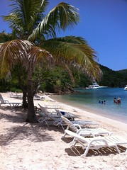
It's the weekend! What a week. Lots going on at work and CYOA. So I'm defintely ready for the weekend. Jay works tomorrow so I get to go shopping for a new fridge for the condo, the one we have is dying. I like the ones the landlord is picking out so I don't mind shopping :-)
We went to Norman island last weekend so this pic is from Pirates Bight. Nice place to hang out and have a cocktail and some food. Our boat broke down after this trip so we won't be going anywhere for awhile :-( Buy that's a whole nother story.
Anyway, have a great weekend!
Friday, July 22, 2011
Weekend Weather

And so it begins......the "season" is upon us. So that means screwed up weather on the weekends. Last weekend we didn't go boating because of weather and it looks like we're in for the same this weekend. A tropical wave is heading our way that will bring rain and choppy seas. Jay is off again this weekend but it looks like no boating. Hopefully it moves through fast so that maybe we can get out on Sunday.
Subscribe to:
Posts (Atom)